Godalming Greenway
Lammas Lands

The local councils have proposed to build a 4m wide compound or raised cycle track through the Lammas Lands and across the river wey.

The proposed development would flow traffic directly from the A3100 down into this designated site of nature conservation importance, and we believe would be a disaster for this protected area.

This sets a dangerous precedent for the future use of our protected common land. The estimated project cost is between £1.5m - £3.5m, with costing for the Lammas Lands portions currently not being available, at least in the public domain.

What people use them for

46%

Walking

24%

Dog Walking

13%

Family Outing

17%

Other

Charity Landing

The Proposed Plans

Two options for the Lammas Lands currently exist under the current proposal, we believe neither to be ecologically sound, compromising natural habitats for logically unsound green points.

A board walk of approximately 3 - 4 metres in width is proposed as an option across the Overgone Meadow (Lammas Lands) to the west of Bridge Rd.

Another option is to provide a bound 3 metres wide path (buff coloured surface) across the Lammas Lands between Catteshall Road and Bridge Road, just south of Godalming United Church.

View the proposed route plan

Nature in numbers

227

Invertebrates

18

At Risk Bird Species

108

Flowering Plant Species

4

Meadows

Protection of Wildlife

A total of 108 species of flowering plants were recorded from the site in 1994, and 227 invertebrates, were recorded from the site in 2001.

Six amber and twelve red BCC listed bird species have been recorded and the site has considerable potential to support additional numbers and species of bird.

The ecologist led management plan emphasises the need for “suitable habitat and disturbance-free conditions”and that “cyclists should continue to be confined to the tow path”.

For a point by point breakdown as to why we believe this is at odds with the management plan, we have outlined it in detail here (on request from Councillor Richard Ashworth).

Learn more about The wildlife
Charity Landing

Why people visit

54.5%

Rural feel

53.1%

Scenery

38.8%

Feels safe

30.4%

Close to local facilities

Charity Landing

As common land

The Lammas lands form an important landscape feature in the town. Residential properties look down on the meadows from the north and south and there are views of local churches, the river Wey and the town from the meadows.

Under the Commons Act, it is the duty of the Waverley Council to ensure that the special qualities of common land, including its open and unenclosed nature, are properly protected. A key part of their role being to ensure that local people will not be prevented from using it in the way they are used to.

Building cycle infrastructure across common land and change of use will require authorization from the Secretary of State under section 38 of the Commons Act and should not be undertaken lightly. The paths will also require necessary public infrastructure (such as bins, waste management and lighting) to ensure security and maintain the pristine natural habitat.

There is huge concern that this proposal sets a future precedent for how the council can use these protected areas.

View all related official documentation

Greenway Consultation

The consultation has now finished, it is however a good resource for official plans and holds all of the comments for the proposals.

As a Flood Defence

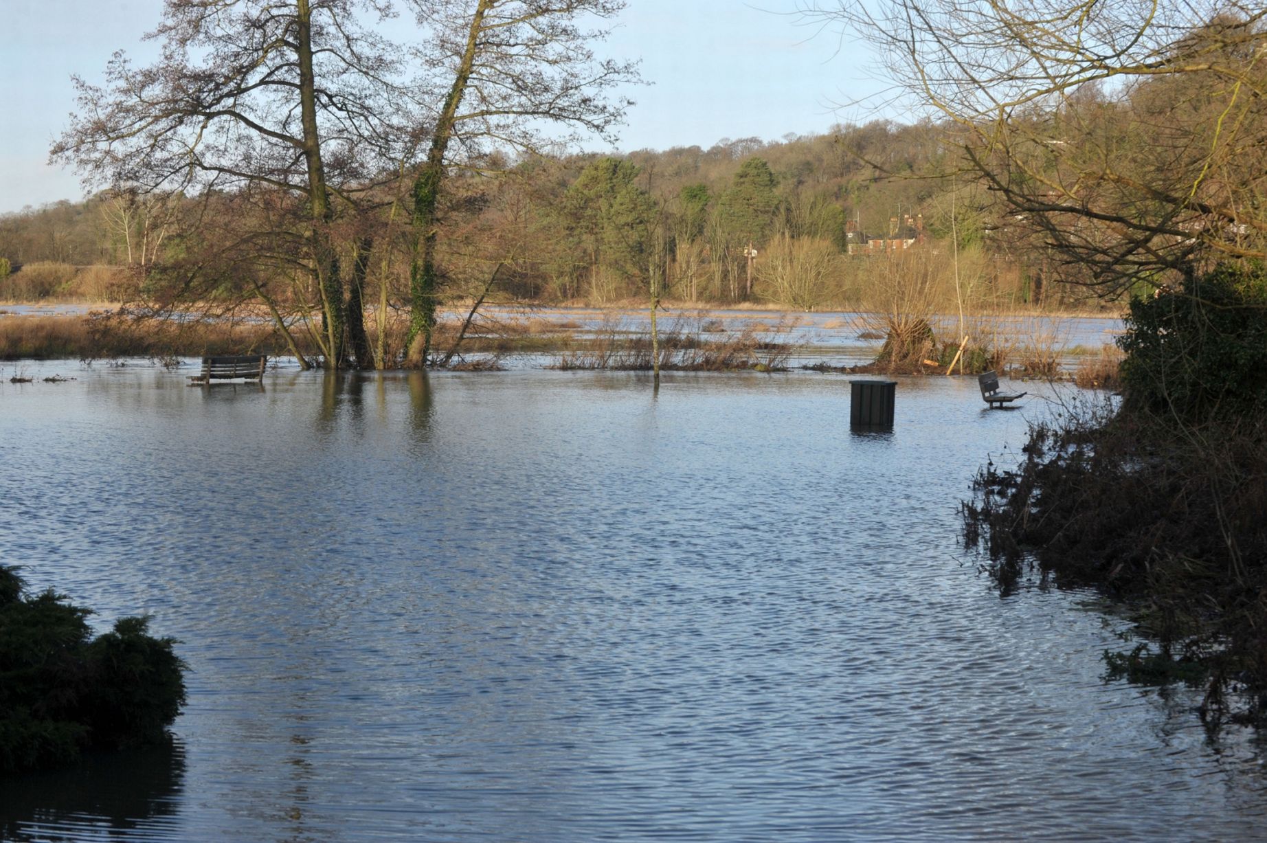
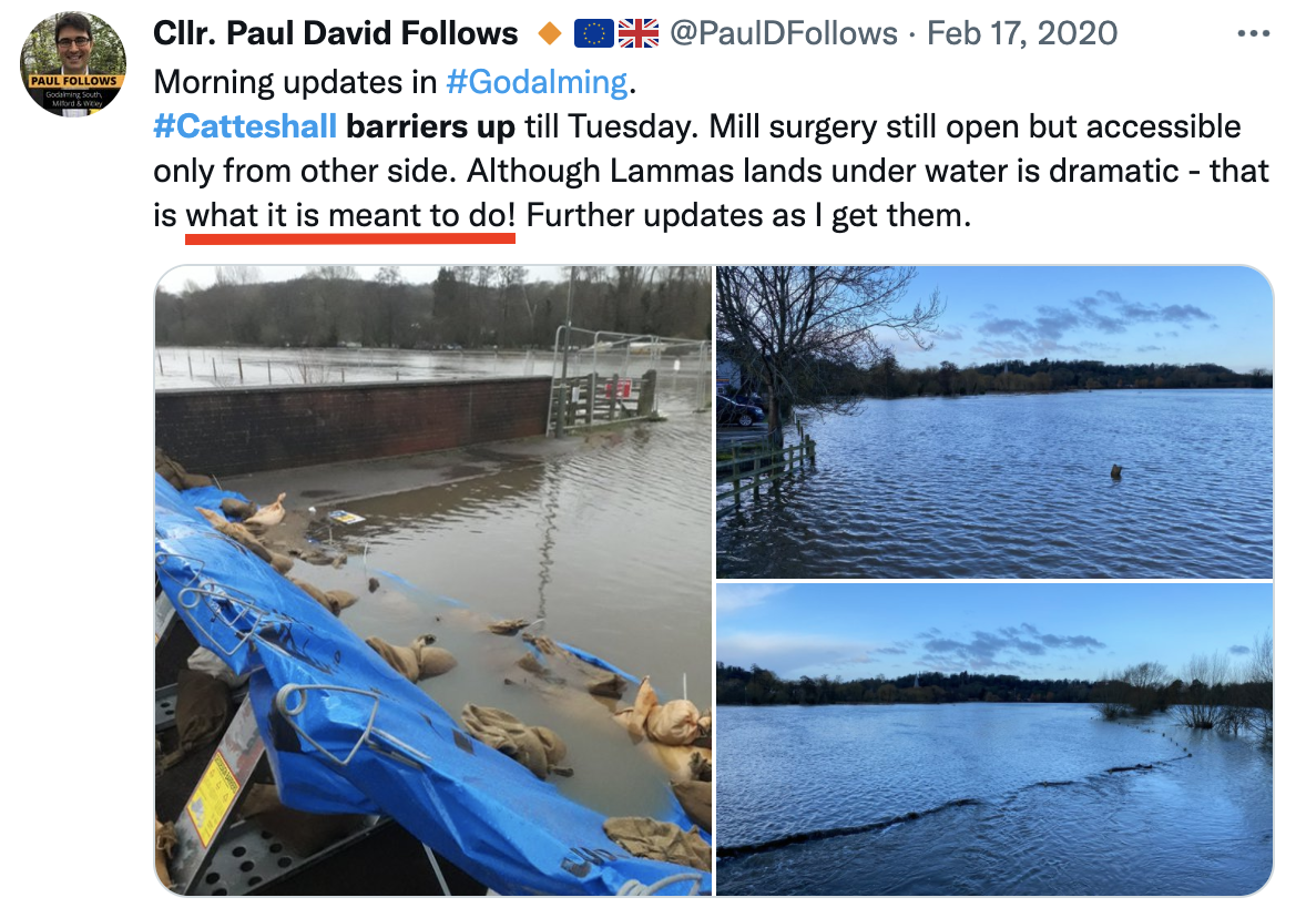
Significant flooding has occurred in Godalming in 1968, 1990, 2000, 2013 and 2020. These events are getting closer together with climate change. During the 2013 flood, 84 properties in the Meadrow and Catteshall area were affected and homeowners evacuated. Residents were out of their homes for many months.

Any act, such as the ones proposed, driving posts to support a boardwalk, foundations or partially surfacing the area will lead to reduced flood storage, this is not a risk (however small) that we should be willing take! Policy CC4 of the local plan specifically states that any construction should not constrain the natural function of the functional floodplain, either by impeding flood flow or reducing storage capacity.

We are unsure that this could even be classified as the kind of essential infrastructure in a (Zone 3B) floodplain that would be recommended by the environment agency and that it would meet the essential criteria after undertaking the Sequential and Exception Tests. Read our in depth analysis as to why we believe this to go against Environment Agency guidance here.

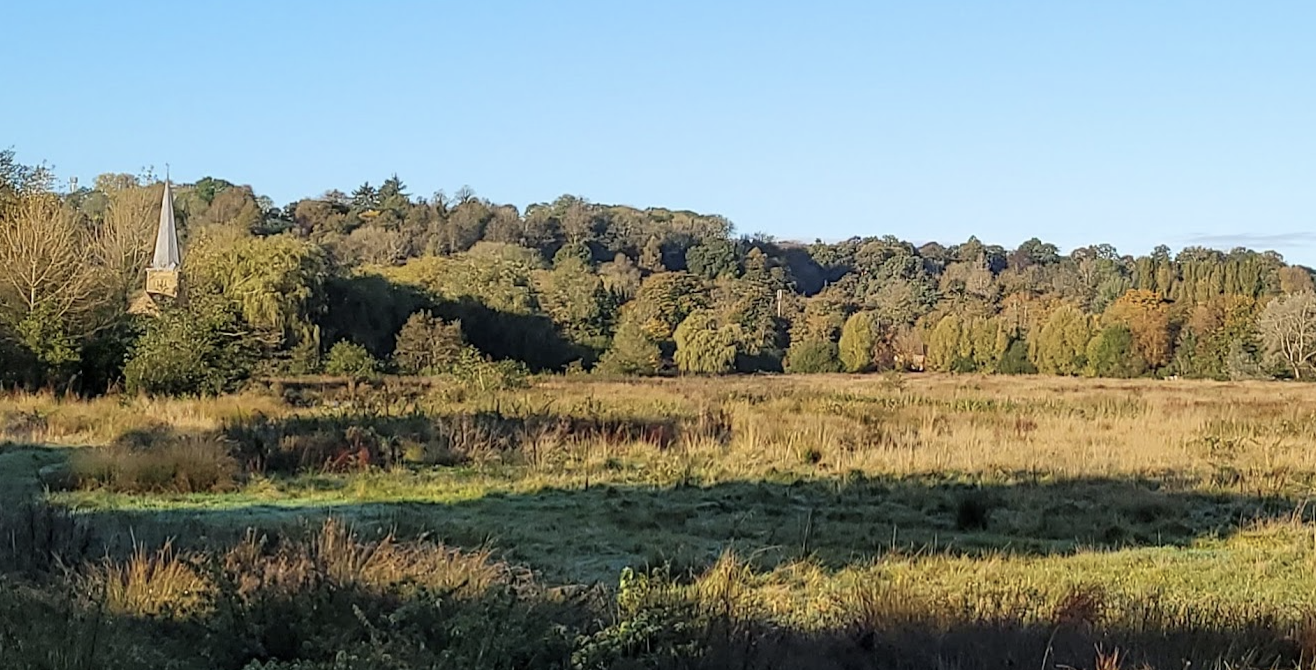
The Lammas Lands are recognised as a vital part of the flood protection measures of the town and even a marginal increase in flood risk is not acceptable. The Environment Agency dictates no net loss of floodplain storage, at the council(s) own admission this project will lead to a marginal reduction.

Learn more about the Flood Defences
Lammas Lands FloodingPaul David Follows tweet of Lammas Lands flooding

Public support for future management

87.7%

Floodplain management

87.7%

Habitat Management

83.6%

Volunteer Group

91.7%

Cattle Grazing

Charity Landing

Protected View of St Peter and St Paul Parish Church

One aspect raised by the community through the Godalming and Farncombe Neighbourhood Plan (2019) engagement process was the importance of protecting valued landmark views.

The plan sets out that development should preserve the historic setting of the panoramic view from Chalk Road/Bridge Road towards the Parish Church of St Peter and St Paul, across the Lammas Lands. Any development which has a detrimental impact on the setting of this panoramic view will be refused.

We sincerely hope that Waverley Borough Council will not go against what was set out as part of the Neighbourhood Plan.

Green Benefits

Surrey County Council have stated the following about the route

"While the route has been selected with utility in mind, most of it passes through scenic landscape making it suitable for leisure as well. However it is not intended that this should be a route for cycling at speed. Fast routes for commuting by bike may be better provided separately."

Our opinion is that of the council(s) own admission, this route would not be suitable for the kind of commuting that it is promising and the reduction in carbon emissions that would come from it. This juxtaposed with the potential harm to the floodplain function, surrounding views and natural habits make this an inadequate response to decreasing daily car usage.

Charity Landing
Charity Landing

Prior Consultations

As part of the Godalming and Farncombe Neighbourhood Plan (2019) traffic calming measures were suggested and have not been implemented, specifically on Bridge Road.

The ecologist led management plan and visitor survey consulted 219 people who actually use the Lammas Lands, rather than cyclists from Guildford. The overriding sentiment from these was that the key focuses should be habitat management, floodplain management and cattle grazing. They also suggested extra turnstiles and volunteer groups, to help locals become more educated about their surrounding nature.

It is important that these previous consultations & expert advice are undertaken and that the results and advice are implemented.

Restrictive Covenants

Surrey County Council appear to be ignoring the restrictive covenants in place at Land Registry in their plans for a boardwalk on Overgone Meadow. The key covenant states that,

"not at any time hereafter either to change the use from that of agriculture or to take any action which would encourage public use of the said property (edged red excluding the 4.35 acres between Chalk Road and Hells Ditch)."

These restrictive covenants, in the words of a member of the family that put them in place, were put there to ensure that they remain as farming, grazing and wildlife land. They are very keen for it to stay that way.

Charity Landing
  • Paul Follows

  • Jeremy Hunt

  • Godalming Town Council

  • Waverley Borough Council

  • Surrey County Council

Paul Follows image

full support given

"I’ve backed this from the moment I’ve known about it (and to be blunt I’m one of the reasons it has funding from various places)".

"The waverley sections have the full support of the two councils I lead (Godalming town council and waverley borough council), the support of the waverley Lib Dems and me personally."

The above comment(s) appear to be regarding the entire project (and were taken from facebook), we have sought clarification from Paul. Paul is both the leader of Godalming Town & Waverley councils and is also a member of Surrey County Council. Paul is a resident of Godalming and a member of the Liberal Democrats.

Greenway Consultation

The consultation has now finished, it is however a good resource for official plans and holds all of the comments for the proposals.